 – Germany’s Dramatic Alpine Historical Retreat")


The concept of a river flowing across the sky may sound like science fiction, but it is a real and fascinating natural phenomenon known as the River in the Sky or River of Clouds. This term is commonly used to describe atmospheric rivers, long and narrow bands of clouds and moisture that move through the atmosphere like flowing water. These invisible rivers play a crucial role in Earth’s weather systems and have a significant impact on rainfall, climate patterns, and water resources around the world.
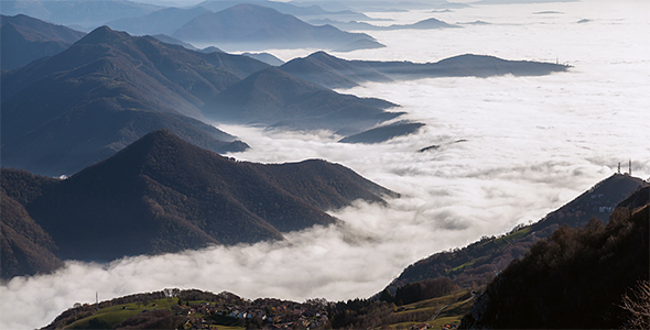
A River in the Sky is formed when large amounts of water vapor are transported through the atmosphere by strong winds. Unlike rivers on land, these atmospheric rivers are made of moisture rather than liquid water. They often originate over warm ocean regions where evaporation is high. As the moist air rises and moves inland, it condenses into clouds, creating the appearance of a long, continuous river stretching across the sky.
One of the most well known examples of a River in the Sky occurs over the Pacific Ocean. These atmospheric rivers can travel thousands of kilometers from the tropics toward continents such as North America. When they reach land and encounter mountains, the moist air is forced upward. This causes heavy rainfall or snowfall, especially in coastal and mountainous regions. In some areas, a single atmospheric river can deliver more water than many traditional storms combined.
Despite their beauty when seen from satellites, Rivers in the Sky can be both beneficial and dangerous. On the positive side, they provide essential water to regions that depend on seasonal rainfall. In places like California, atmospheric rivers are responsible for a large percentage of the annual water supply. They help refill reservoirs, support agriculture, and sustain ecosystems.
However, when these rivers of clouds become too intense, they can cause severe weather events. Heavy and prolonged rainfall can lead to floods, landslides, and damage to infrastructure. Urban areas are particularly vulnerable when drainage systems are overwhelmed. For this reason, scientists closely monitor atmospheric rivers to improve weather forecasting and disaster preparedness.
The visual appearance of a River in the Sky is especially striking from satellite imagery. From above, these cloud formations look like massive white streams flowing across the planet. This imagery has helped scientists better understand how moisture moves through the atmosphere and how interconnected Earth’s climate systems truly are. Advances in satellite technology have made it easier to track these cloud rivers in real time.
The study of Rivers in the Sky has become increasingly important in the context of climate change. Warmer temperatures lead to increased evaporation, which means the atmosphere can hold more moisture. As a result, atmospheric rivers are expected to become stronger and more frequent in some regions. This could intensify both droughts and floods, depending on where and how these cloud rivers release their moisture.
Beyond science, the idea of a River in the Sky has inspired artists, photographers, and storytellers. Time lapse photography and aerial images often capture cloud formations that resemble flowing rivers above mountains and valleys. These scenes remind people that nature operates on scales far larger than everyday human experience.
In conclusion, the River in the Sky or River of Clouds is a powerful and essential part of Earth’s natural systems. Though invisible from the ground most of the time, its effects are felt through rainfall, snowpack, and weather patterns across the globe. Understanding this phenomenon helps scientists predict extreme weather, manage water resources, and better prepare for the challenges of a changing climate. The River in the Sky stands as a reminder that even the air above us is constantly moving, flowing, and shaping life on Earth.