


Picture an island rising from the sea, cradling a lake that holds yet another island. This nested geography defines marvels like Taal Volcano in the Philippines, where volcanic activity creates lakes within islands surrounded by ocean. These formations challenge our understanding of landscapes, blending geology, ecology, and human history. This in-depth exploration covers their formation, biodiversity, and tourism appeal, essential reading for geography aficionados and adventure seekers.
Geological Formation and Volcanic Origins
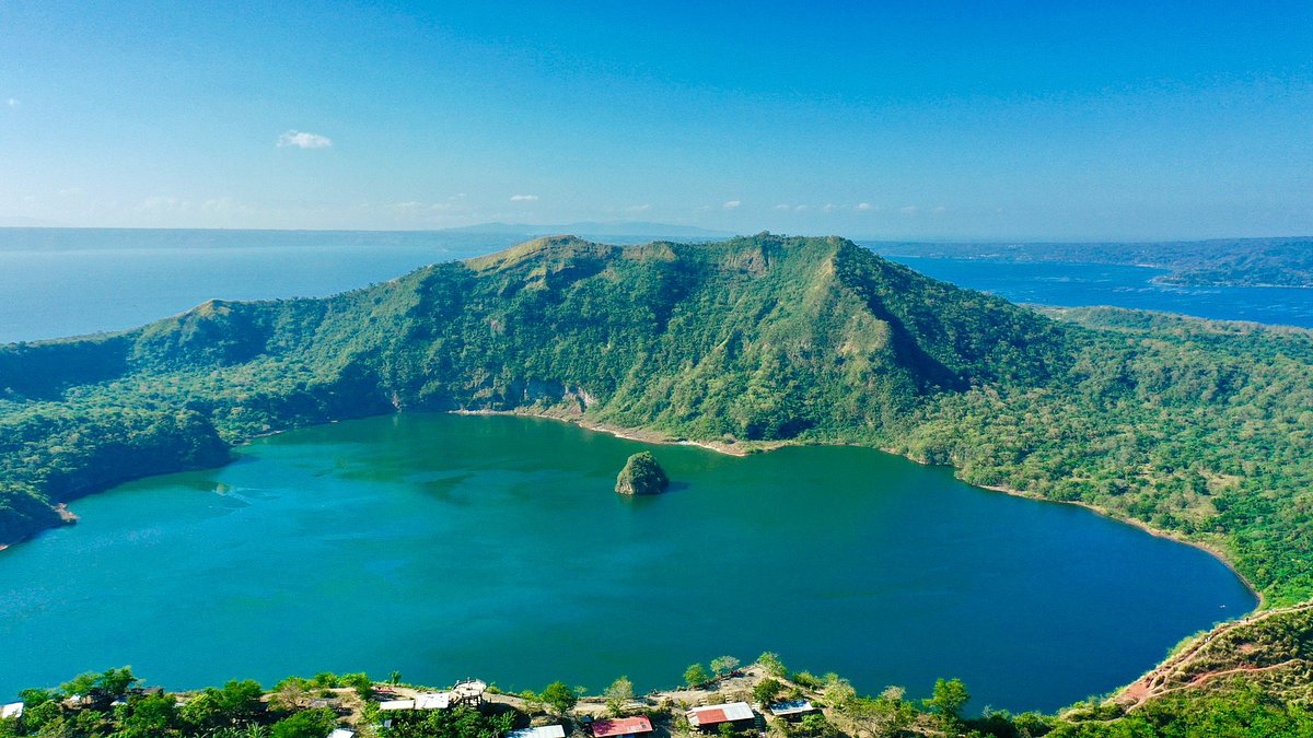
Taal is a caldera volcano on Luzon Island, with Taal Lake filling the caldera. Volcano Island within the lake has its own Crater Lake, and tiny Vulcan Point island sits inside that. Formed by explosive eruptions over millennia, the last major one in 2020 reshaped the area.
Geologists from the Philippine Institute of Volcanology and Seismology (PHIVOLCS) note hydrothermal activity keeps waters acidic and warm. Similar sites include Indonesia’s Lake Toba or Oregon’s Crater Lake, but Taal’s sea proximity makes it unique—essentially an island-lake-island in the Philippine Sea.
Biodiversity and Ecological Significance
Taal’s ecosystems host endemic species like the Taal Lake snakehead fish and migratory birds. The lake’s alkalinity supports unique algae, while surrounding forests harbor Philippine deer and monkeys. Volcanic soil enriches agriculture, growing pineapples and coffee.
Climate change and eruptions threaten biodiversity. Ashfalls alter water chemistry, impacting fisheries. Conservation by the Department of Environment and Natural Resources includes protected zones.
Human History and Cultural Impact
Inhabited for centuries, Taal’s shores feature Spanish-era towns like Talisay. Folklore depicts the volcano as a temperamental deity. Colonial history saw it as a strategic site, now a tourism hub.
Communities rely on fishing and farming, but eruptions displace thousands. The 1911 eruption killed over 1,300, shaping resilience narratives.
Tourism and Adventure Opportunities
Taal attracts hikers and boaters. A ferry to Volcano Island leads to trails overlooking Crater Lake. Post-2020, access is restricted, but viewpoints like Tagaytay offer panoramas. Similar destinations: Nicaragua’s Ometepe Island in Lake Nicaragua, though not oceanic.
Safety is key—monitoring apps track activity. Eco-tourism promotes sustainable visits, funding conservation.
Environmental Challenges and Future Outlook
Pollution from urbanization affects water quality. Volcanic risks prompt evacuation plans. Global warming may intensify eruptions, per IPCC reports.
Research uses drones for mapping, aiding predictions. International collaborations enhance understanding of such nested features.
Comparative Global Examples
Beyond Taal, Alaska’s Kaguyak Crater and Papua New Guinea’s Ritter Island offer parallels. These sites highlight Earth’s tectonic creativity.
In closing, islands with lakes in the open sea like Taal are geological poems, layering land and water in symphony. They inspire awe and caution, urging preservation for future generations.